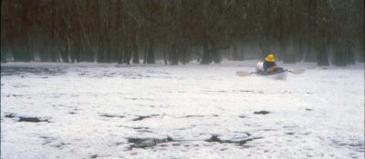
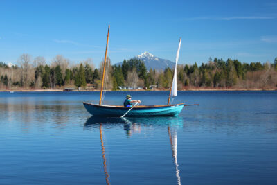
Whenever my daughter Alison comes home to visit, I enjoy taking her to the airport at the end of her stay. During the 30-minute drive I get a chance to have one-on-one conversations with her and, because she’s a digital native, I also get updated on developments in technology. On our drive this past December, I was surprised to see her answer a phone call by talking into her watch, just like Dick Tracy did with the two-way wrist radio that he stretched out from the sleeve of his yellow trench coat. As usual, I asked Ali to check the traffic ahead on her smartphone to make sure we were on the best route to get to the airport without traffic delays. She brought up the app and when I glanced at her phone’s screen, I could see the blue bull’s eye indicating where we were with the map sliding in the background. I noticed there were other similar dots, something I hadn’t seen during previous drives. Ali told me they indicated the locations of her friends and other family members.Ali mentioned that when one of her friends had gone on a first date with someone new, she and other friends tracked her in real time, and if the route her dot took gave them cause for concern, they could call her to see if she was okay and find her if she needed help. And in late November, while all of us in the family were waiting to hear from my son Nate about the birth of his first child (my first grandchild), Ali was watching, in real time, the signal from his wife’s phone as he drove her to the hospital for the labor and delivery.In the ’80s, when I did my longest cruises, that technology didn’t exist. I could keep track of where I was only by paying attention to my surroundings and keeping an eye on my chart. And, for days if not weeks at a time, my friends and family back home wouldn’t know where I was.
Join The Conversation
We welcome your comments about this article. To include a photo with your remarks, click Choose File below the Comment box.
You have expressed the dilemma very well. “Tendrils” act upon you without your awareness; even when one becomes aware of the symptom and the cause, it is hard to grasp the full consequence until, over time, you come to realize you’ve lost the part of the experience that connects who and what you are to the place and time. It’s like riding around in a glass bubble. Relying on one’s self makes you put your own tendrils into the landscape; a connection never to be forgotten, as you say. Thanks for writing, as always.
Great article, Chris. It’s good to learn all of this history about you, an extraordinary adventurer. Coincidentally, I am just about to purchase a handheld GPS to enhance my gunk-holing excursions, although my history is a serious dead-reckoning navigator.
I guess we all eventually cave in,
Don Sullivan
Lovely last line!
I really enjoyed reading your article. It reminds me of time spent with my own daughter, just 6 years old. She does not have her own phone or tablet but is well aware of modern technological communications and conveniences. Sometimes when I am driving with her I turn off GPS and let her give me directions on where to go. It is a rewarding experience for both of us. Her confidence grows and I get to experience the world though the landmarks that she recognizes as important.
Ahh, getting lost is a lost art.
Thanks for the great story, Chris. Could you share the route that you followed during the Quebec to Florida journey? Any strategic portages (e.g., Pont-du-Chene to Moncton), or simply following the coastline?
The route was entirely inland and required only three portages. Here is a brief itinerary:
Québec City
St. Lawrence River
Richelieu Canal
Lake Champlain
New York State Barge Canal
Hudson River
Delaware Raritan canal (short portage on the west end by good Samaritan truck)
Delaware River
Chesapeake and Delaware Canal
Chesapeake Bay
Dismal Swamp Canal
Intracoastal Waterway
St. Marys River (portage on the west end by good Samaritan truck)
Okefenokee Swamp (haul over west levee)
Suwanee River
Gulf of Mexico
Cedar Key
The distance paddled was roughly 2,500 miles and took 4 ½ months.
What an epic adventure! I was looking thru your itinerary with Google Maps, and I am intrigued by Okefenokee NWR. The park map on their website shows a connection to the upper Suwanee river, but none with St. Mary’s River. I am curious if you remember where your take-out was on St. Mary’s. Did you take out near Folkston, where the river passes near the east road entrance to Okefenokee, or did you continue until St. Mary’s turns back north and enters into the NWR at the southeast corner?
I don’t recall now where we left the St. Mary’s River. Some good samaritans who lived on the river knew about the gap between the river and the swamp and gave us a ride, boats and all, in their pickup truck.
I really like the description of critical points of this journey and I am impressed by the solutions to find your way. I grew up in east Germany, a place where it was hard to get lost and even harder to have good technical equipment for weather forecast and navigation until 1989. Being now able to navigate, to stay tuned and to keep in contact and to be aware of changing weather is a chance. I often sail with crews that are inexperienced or with children. Starting an adventure and being responsible at the same time means preparing and adapting to all conditions that threaten a crew. So these little helpers are a welcome backup when the paper chart doesn’t help.
My opinion is that with GPS, no one actually knows where they are. They turn off listening to a sense of direction, and follow the arrows. GPS users may see scenery, but aren’t engaged the same way. I never use it. Even to plan a trip, after I realized it always selects for the fastest, most boring path. Screens don’t reveal relative position the way maps do, and when I’m on a trip, I want to fully be on the trip. Turning off the part of your brain which problem solves a path to a goal may leave room for other things, but do you use that space to ponder the meaning of life, or vibe to whatever soniscape the entertainment industry has filtered for you? GPS has reduced traveling to the level of connect the dots pictures. If you like boats: be part of the environment instead of adding another prize to your cocktail-party list.
I do not agree today’s technology brings advantages in safety. Only going where a person feels they have the ability to get themselves out: that’s safety. Only being with someone you already feel safe with: that’s safety. And keeping alive the section of our brain dedicated to our personal safety: that’s true safety.
My wife refers to it as “Wandering, not lost.” For many years I sailed without electronics, just paper charts and a compass. While I carry a handheld GPS and an app on my phone, I still prefer paper charts. In the bays and modest streams where I do my small boat paddling, I just navigate by eye without charts. I still enjoy the challenge, even in fog.