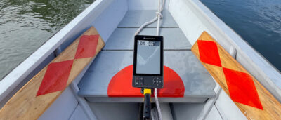
When I bought my first handheld marine GPS (a Garmin 12 in 2000), I thought, like many of us in fog-bound Maine, that I now had the ultimate answer to kayak and open-boat navigation. I regularly swapped it for newer handhelds as features were added or mine broke. Then last summer I heard about Maptattoo, a promising new chartplotter specifically created for small boats. It was being crowd-funded and I sent in a deposit to reserve one.The Maptattoo was designed to address the difficulties its developers encountered using a tablet in the 2018 Race to Alaska (R2AK). The first issue was visibility. If you’ve used a dedicated handheld tablet or smartphone to navigate, you know how frustrating it is to read an LCD screen in bright sunlight. Reflections make it difficult enough; with dark glasses it’s almost impossible. Power management is a challenge, with LCD screens needing plenty of power when running at full brightness. Batteries require replacing or charging, and on small, often wet boats this can be a problem. Handhelds that run 19 hours or so on a couple of AA batteries are fine for a day’s outing, but beyond that, the batteries need to be replaced or recharged. Despite manufacturers’ claims of watertightness, their handhelds’ battery boxes eventually fail, as my numerous dead handheld GPS units can attest, even when I’ve operated them in windowed dry bags, which also worsened visibility.The Maptattoo developers had several goals: a large screen with visibility even in bright sunlight, a multi-day battery, watertightness, impact resistance, and the ability to be operated with a wet finger or push-buttons. For readability and low-power consumption they settled on the only technology that provides both: E Ink, the black-and-white screen technology used for e-readers like Kindle.
Join The Conversation
We welcome your comments about this article. To include a photo with your remarks, click Choose File below the Comment box.


It looks like an interesting device that solves many of the problems of hand-held navigation. Do the developers have a timetable which includes distribution to, and charts for, Western Europe?
I suspect so; post a question on their web site. One of them is French so that should help.
I’ve seen the marketing info but this is the first hands-on from a reviewer. Thanks Ben!
It will be interesting to see how many of the open-boat entrants in next week’s R2AK will be using this device.
My 15-year-old Garmin handheld finally died due to sun-damaged pixels and battery-compartment corrosion. I considered getting Maptattoo. It would be similar at showing big numbers for speed and heading, but far better than the tiny chart display. Research showed two issues: First, chart coverage is limited. US lakes are scheduled to be added soon, but the database will have only a few for my state (CA) and no plan yet to add the rest. Second, the manufacturer advised not exposing it to full sun on hot days. On an open boat in CA that is going to happen. I got another small handheld, backed by my existing coated-paper charts and Navionics on the phone if an up-to-date chart was ever required. That is sufficient for my local waters.
Just was sent and installed the next major software upgrade to which I alluded in the review that it was coming. It’s too bad that while the salt-water data is pretty accessible through the international hydrographic office, inland lake information is not and costs to add it. My guess is that Europe will be the next area where charts are added.
Thanks for putting this review together, Ben. Since the idea for this device began with the R2AK, have you seen any user comments from the R2AK that’s currently wrapping up? I didn’t see anything on their website as of the end of June.
This will be a great improvement over grabbing for my phone, which I can’t read with my polarized lenses while rowing. And could be a great backup to the aged Garmin in the stinkpot.
I also got a Maptattoo early on, as a so-called crowd-funder. The founders were and continue to be as responsive as their resources (being a tiny two-person company) allow to problems, feedback, and input. I had been procrastinating on investing in a portable GPS for paddling and sailing for some years, for all the reasons Maptattoo addresses (battery life, daylight readability, weather-proofness, ruggedness, all-conditions usability). A further motivation for me is that Maptattoo runs on a linux-based operating system, instead of the proprietary and exploitative Android or iOS operating systems used by smartphones or tablets. There are still a few basic functions missing, but I trust that future software updates will add those, as other requests by early users have been added in previous updates.