As always, there had been a rough sketch of a plan: a 7- or 8-mile row, heading generally northward through the meandering sloughs and backwaters of the Chippewa River delta, the largest contiguous floodplain forest in the Midwest. From there, it would be an easy float down the main river channel to its junction with the Mississippi. Two or three nights aboard, a wandering pilgrimage through 30 square miles of river bottom forest and wetland bisected by only a single road. No need to pack the sailing rig—oars alone would do.The more I thought about it, the better it sounded. With no charts available, I downloaded a set of detailed topo maps, printed them at 2″ to the mile, and ran them through a laminator. A bit smaller than restaurant placemats, and stiffened nicely by the laminating, they’d be perfect for one-handed use in a small boat—a trick I filed away for future trips. Even better, the maps seemed to suggest that the route I had imagined might actually exist. From a launch ramp 50 yards off the south side of Highway 35, a reasonably open channel paralleled the road eastward for a mile or two, snaking back and forth beneath a series of bridges before entering a thin but apparently continuous ribbon of river leading farther north. Many of the channels leading north from Highway 35 were so shallow that I could stop FOGG, my Don Kurylko-designed Alaska, in midstream, with no need to tie to shore. Sandbars and shallows were so frequent that wading upstream while pulling the boat behind me often turned out to be the only way to make any real progress.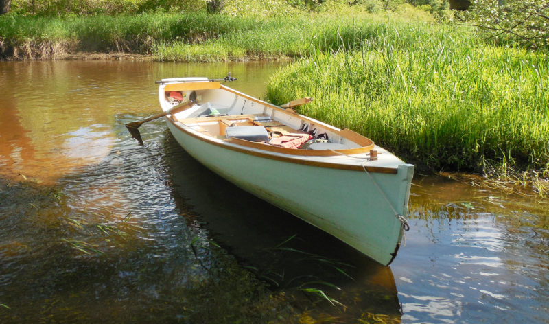 Photographs by the author
Join The Conversation
We welcome your comments about this article. To include a photo with your remarks, click Choose File below the Comment box.



Tom, wonderful photos, video, and journal! I saw the “sandpile” on your map but the video makes it so that it should be renamed “sand mountain,” no? Excellent footage!
I’m wondering if any critters came around your camp sites during the night ashore? On some if my journeys I’ve been expecting to wake up with a sniffing coon next to my ear! And on that one journey I too had trains running during the night on the opposite side of the river (Potomac, C&O canal). As always Tom – thanks much!
Rob
Rob,
Thanks for the comment and the kind words. Wildlife? On this trip, I saw lots of beavers. They aren’t too shy if you’re quiet–one of them swam right by my campsite the first night. Lots of bald eagles, too.
How’s your Ilur working out? Did you end up taking delivery in August?
Tom
As usual, Tom, a great read – even if it might not have been a ‘great’ trip. Given that the world might become more sane, perhaps next year will feature another trip to the vast, and deep, Canadian waters?
John
John,
Thanks for the kind words–I appreciate it. Of course, I rely on the editing team at small boats to help shape the story and try to make me look better than I really am!
As for a Canadian trip, let’s hope so. I’ve got a long outing I’d really like to try, on some big waters farther north. I’m watching Omicron develop with a bit of trepidation over what it might mean for travel plans this summer, though…
Tom
Also: actually, it WAS a great trip, despite the dead ends. It’s the wandering around I enjoy, much more than any specific destination. A good excuse to laugh at myself for doing something so ultimately pointless, and enjoying it so much!
G’day Tom,
I’ve just re-read this article for the third time (I think) and each time I enjoy it just as much as the first. If you are enjoying the trip as you so obviously do, then it is not pointless, the enjoyment is the point. But then you knew that.
Tom, you are an artist and the water, FOGG, nature, and words are your media. Especially words.
Thanks for sharing,
Wayne
Gippsland in Victoria, Australia
A beautiful journey, Tom. Thank you for sharing. I know this special feeling of exploring well: At the upper river Rhine in Germany, where I live, we have a lot of old waterways beneath the main river, that are connected – or not. When I see an opening, I follow with my canoe, fighting and struggling aganist dead trees, mud and nettles, As long as there is current, there is hope. And like a child I expect an exiting thing behind every corner: a lost bunker of WWII, an abundand castle – or at least an old garden house 🙂 Even if it’s in reality a trip of only hundred meters with three portages, they are full of adventures … but I would never try this with the dory that is much lighter than your boat.
Gerald,
Thanks for the comment. That seems to describe this kind of small-water cruising very well. I’d love to get to the Rhine, and the canals of Europe with a boat.
Tom
Good read, as usual. I’d like to go up in Canada on a trip myself-but anchoring in a cove is the same as stepping on shore. Last year Ontario allowed fishermen in Canada but no stepping on shore without tests and shots. Not sure if the ArriveCAN will work for overnight stays.
It is surprising how similar this landscape is to what we have here in Ontario. This reminds me of the Minesing swamp—at the confluence of the Nottawasaga River and Willow Creek, west of the city of Barrie—where I made it a habit of going every spring in April/May when the water levels are so high that the rivers disappear and one can float through the woods accompanied by the same bird calls heard in this video clip. You had plenty of red-winged blackbirds around, it seems. I use a canoe, which is much lighter and the shallow draft allows getting to places impossible to reach otherwise in a swamped landscape.
I will watch the video from time to time during the winter months—nothing better to beat the blues.
Thanks for the great read.
Thanks for the comment. Yep, red-winged blackbirds and bald eagles were the ones I heard/saw the most. Blue herons, too. A canoe would have made some of this trip a lot easier, for sure! But easy doesn’t necessarily make things fun. Your trips through the flooded woods sound great.
Tom
This sounds like a great trip, full of the kinds of failures that make you appreciate what it must have been like to navigate uncharted waters in the early days before maps were available. Thanks for a great read.
William,
thanks for the comment. It would be a fun experiment to go out on a long trip without any maps at all. Maybe some day I’ll try it.
Tom
Watching you load those bags into the boat, getting ready to shove off for another day. Great stuff ! Thank You !
What a fun read, even the second time through! I’ve had many experiences similar to yours, but on a motorcycle. Here in Vermont, there are maps, and then there is the real world. Sometimes the two are close, sometimes not! As you say, the fun is in the exploring, regardless of how many miles are covered. I recently retired, and have now built a small rowboat and a kayak, so my rowing and paddling days are just getting started.
Thank You for sharing your adventure!